Roman Road Investigation – A59 to Coal Pit Lane, Rimington; part of Margary 72a
Report on investigation into possible agger in using probe technique.
Participants
B. Jeffery, P. del Strother, L. Marklew, T.Marklew.
Background
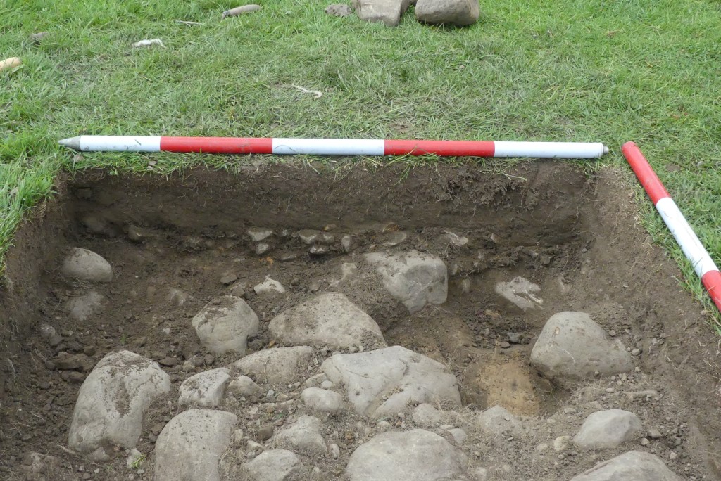
During a survey of the Martin Top and Howgill area on 11th June, two Test pits were dug in which 3 contexts were found; these being typical of the way in which a Roman Road could be constructed. It was felt that further investigation by way of selected probing exercises, using a revised recording form, would be good practice for novices whilst the outcome would inform those with more experience.
A probing exercise carried out on 11th June was felt to be inaccurate because the weather conditions under which it was carried out made the exercise difficult, therefore a second more accurate attempt was to be completed.
Thus:
1. A field exercise was carried out in order to test the appropriateness and practicality of a revised form designed to record the results of surface and underground profiles. Some refinements had already been made to improve its value for ease of use by novices in the field.
2. Having found consistent stony resistance in an area further down the hill by exploratory probing, where again the first OS map and Lidar indicated the possibility of a Roman Road roughly WSW of Test Pits I and 2, it was decided to establish the profile both of the land surface and the underground stony profile in order to discover whether a similar construction to that found in pits 1 and 2 might be present.
Methodology
1st profile recording by test pits 1 and 2 (see post on test pit results)
Following the line of the Roman Road established by the first Ordnance Survey Map and the Lidar profile, the probable agger had been located by opening Test pits 1 and 2.
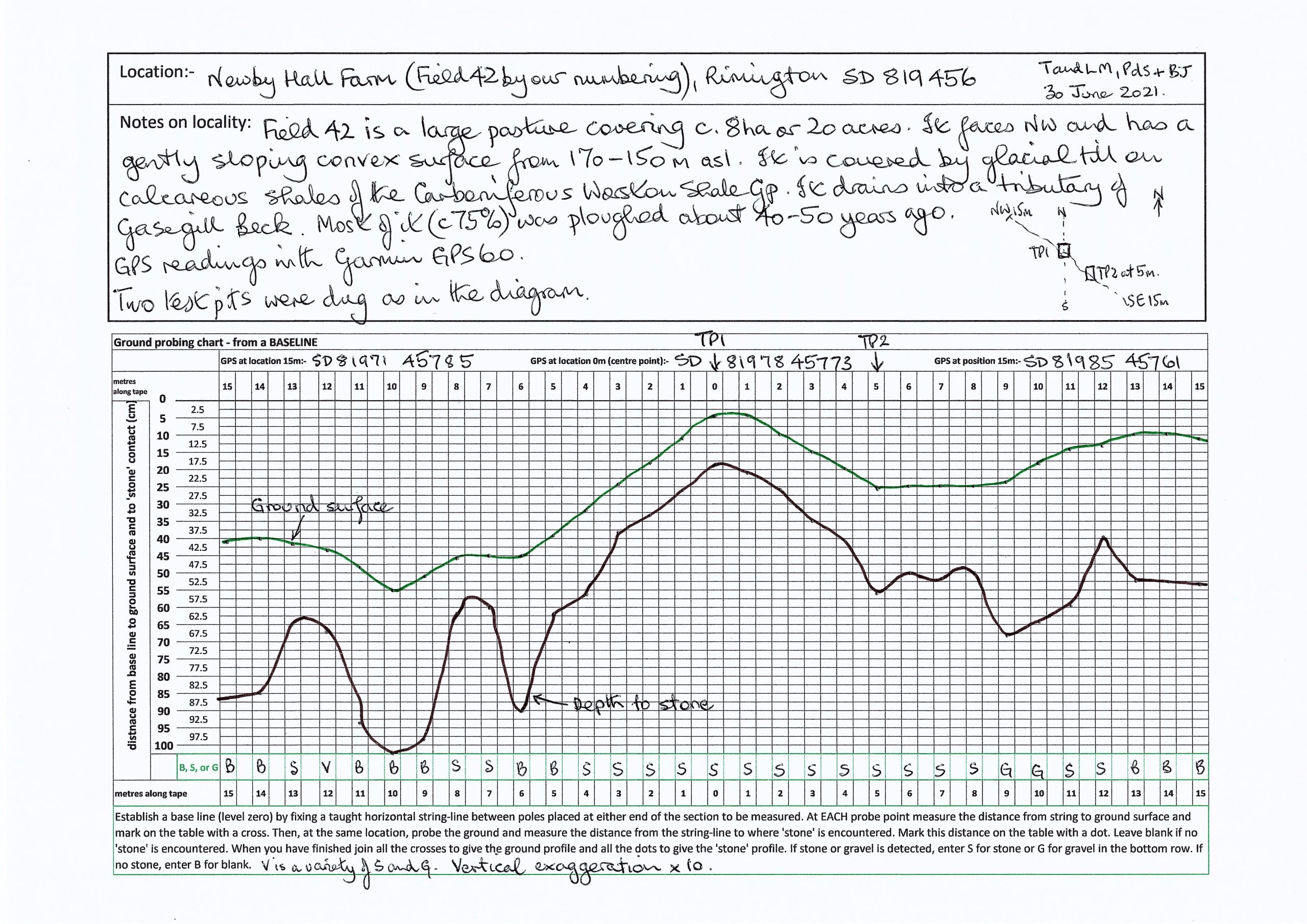
A centre point on the agger at GR SD 81978 45773 was selected and marked by a pole. A measuring tape was laid out 15 metres either side of the pole, at right angles to a line running 66 degrees ENE; 246degrees WSW; the line along which the Roman Road appears to run.
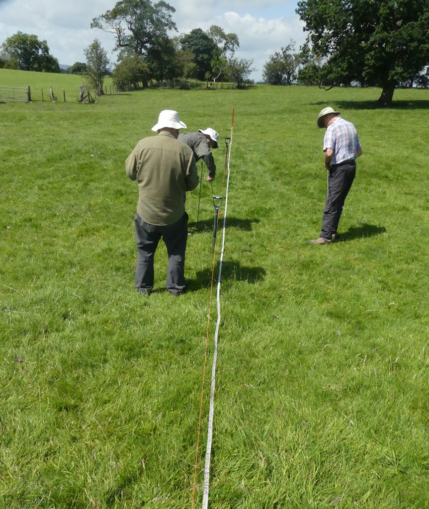
A base line was established from the centre point pole where a piece of orange string was tied as near to ground level as possible and run out to supports at 5,10 and 15 metres on either side, stretched tautly between the supports and tied. Along each section the string was levelled using a simple plastic spirit level, approximately at the centre point.
Working from the centre, zero, on the recording form, measurements were recorded at every metre to GR SD 81985 45761 to the east, then to GR SD 81971 45785 to the west,
At each probe point the distance from string to ground surface was measured and marked on the form with a cross. At the same location, the ground was probed and the distance from the string line to where ‘stone’ was encountered was measured and this distance was marked with a dot. A blank was left where no ‘stone’ was encountered.
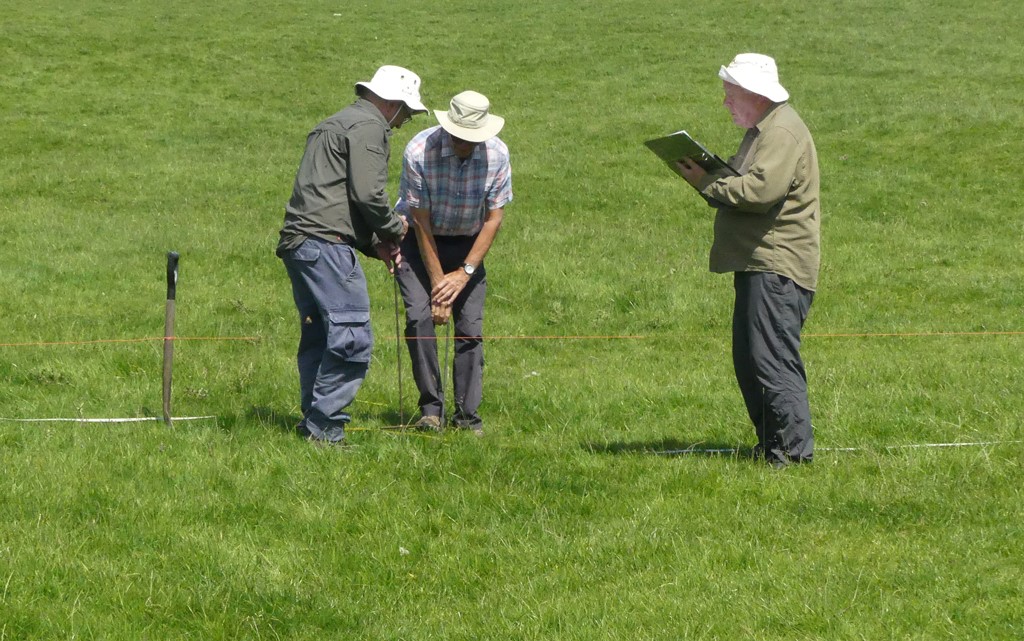
Occasionally it was felt to be helpful to make several probes close to the metre mark in order to confirm the response.
On completion all the crosses were joined to give a ground profile and all the dots to give the ‘stone’ profile. Particular note was made of field boulders, marked ‘Boulder’; stony surfaces, marked ‘S’; gravel marked ‘G ’and various surfaces marked ‘VAR’, whilst no stone was marked by ‘B’ for blank.
Profile:

2nd profile recording in same field near to west side fence
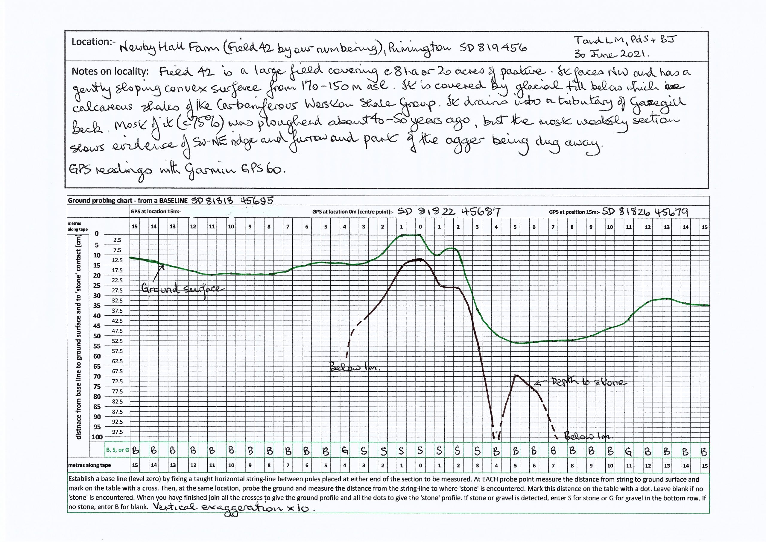
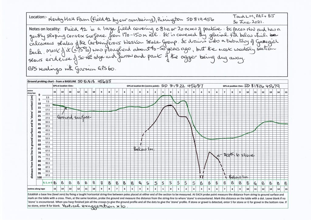
Following the line of the Roman Road established by the 1840s Ordnance Survey Map and the Lidar profile the probable agger was followed downhill in an approximately WSW direction and a similar procedure was carried out from GR SD 81822 45687 to GR SD 81826 45679 to the east and to GR SD 81818 45695 to the west.
There is a gap in the agger just above the position of profile 2. Nearby is a small building, Wolfendale, and it is a possibility that some of the road stones were used in the building of that.
Results and observations
1. The form for recording the results of probing was found to be both practical and helpful. One or two refinements were found that could be added, namely, some form of demarcation on the tabulation lines to aid location of dots and crosses, adding the depth readings on the right hand side as well as the left, if room allows, and finally, adding a small directional box which reflects the orientation of the profile. Since similar profiles are likely to be done along the total section of road under investigation consistency of profile orientation is important.
In the first levelling exercise, the central raised hump of what could be a section of an agger above ground, is reflected in the stone profile below ground, which is further confirmed by the context findings in Test pit 1, (see report June 11 th )those being a metalled small stone layer of approximately 3 – 4 cm diameter lying above river washed cobbles which are set in a base of creamy yellow clay, all of which make it a possible section of the Roman Road. This invites further inspection of the quite noticeable ditch like formations either side of the approximately 16 metre wide hump and after which the findings of TP 2 may be further clarified. On the east side there is stone, as TP2 showed, whilst on the west side the stone layer disappears more quickly.
3. In the second levelling exercise, whilst the profile of both land and the stone beneath show a small hump, this is very narrow; only approximately 7 metres across, either side of which the stone contour disappears quite quickly and is replaced by firm and soft earth, so should this have been an agger then the borders of the road are inconclusive. It is possible that on the land there has been upheaval, either by water coming downhill, or that of water drainage pipe installation which it is believed took place.
Recommendations
1. With a few minor changes the probing record form is a good method of recording on site and of presentation of the resulting profiles.
2. The profiles at TPs 1 & 2 confirm this area as worthy of further investigation. The orange string used in levelling proved difficult to see from a distance, therefore other levelling lines could be tried.
Lesley Marklew 6th June, 2021