Seven people (Barrie Tyrer, Louise Mills, Trevor & Lesley Marklew, Brian Stott, Ian Rowley and Brian Jeffery) visited with the kind permission of the farmer.
Aim:
The aim was to investigate a section of the supposed RR ‘agger’ which crosses a field in a WSW-ENE direction along a bearing of 66 degrees magnetic . The field faces north has a gently sloping, slightly concave surface, and varies in height from 145-165m or 475 to 540ft. It is underlain by the calcareous mudstones of the Worston Shale Group which are steeply-dipping to the north at 80 degrees. These rocks are topped with about 3-4m of glacial till. The field has no obvious drainage, but any surface water would flow overland into Gazegill or Rimington Beck. The contours on the 1844 OS map suggest that there was once a surface stream fed by a well. On Lidar, the surface shows traces of shallow water channels or surface sheet flow. Most of the field was ploughed in WW2 and afterwards for the growing of wheat. It has frequently been ploughed to a shallow depth of 15cm, according to the owners, for re-seeding for pasture. The shoulder of the field where we decided to work, we were assured had not been ploughed in living memory.
Objectives:
The objectives were to level across the supposed ‘agger’ to find its elevation above field height and to excavate a 1m test pit to ascertain the construction of the supposed Roman Road. In the light of the findings, a second 1m test pit was dug a few metres to the south as a control.
Methodology:
Using poles, a long and a short tape measure, a hanging level and high-visibility, stretch-resistant string, the elevation of the ‘agger-like’ hump was measured. From the level string, the depths to soil top and any buried stones were measured every metre and written on the prepared recording sheet. The farm’s access road shows a distinctive hump, which was assumed to be the ‘agger’ crossing it at 90 degrees. The levelling exercise was found to be difficult, because over the length of the chosen transect, there was a considerable change in altitude. The scale on the recording sheet was altered from an exaggeration of x10 to one of x5.
This hump or terraced area was about 5m wide. Prodding to find the depth of any stones across and beyond the transect found that outside of this 5m area, there appeared to be no stones in the top 40cm of the soil. It was decided to excavate 2 test pits.
The 1m TP1 was centred on the highest point of the supposed ‘agger’ and exposed to a depth of approximately 30cm top soil and a clayey-subsoil with only 2 stones. Similarly, TP2 showed a similar profile and both test pits were back-filled.
Day 1 discussion:
Test pit 1 was excavated into the hump-like structure which is aligned on 66 degrees magnetic and this agrees with the supposed Roman Road route as shown on the 1849 OS map and on Lidar. Both the test-pits revealed material suggestive of a ploughed-field with little stone.
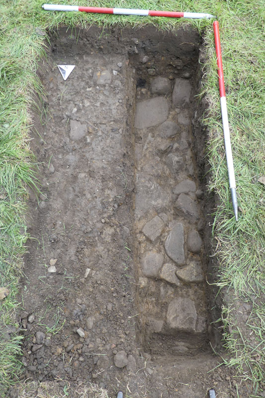
On Day2 (04 Sep), the alignment of the Roman Road was checked and it was decided to dig another test pit nearer to the field edge. Below 20cm of top-soil (context 1), there was a 10cm compacted layer of small angular and sub-rounded stones (context 2), which were difficult to interpret. Below that was a layer of yellow clay (context 3), which appeared to be till.
Despite being so inconclusive, it was decided to extend the TP for another metre in a southerly direction and eventually this became a trench 4m long. As we moved south and upslope, we moved through the clay layer (context 3) to reveal a layer of large rounded cobbles (context 4). These varied in size from 10-30cm. The presence of a clay layer and a layer of compacted stones and clay above the cobbles (contexts 2 and 3) could not be explained.
The trench was temporarily back-filled in anticipation of extending it further in a southerly direction at a later date.
Day 2 discussion:
Despite the lack of evidence in the first half of the day, largely due to the shallow nature of the dig, the afternoon’s sondage brought results. It was agreed to continue digging in a southerly direction as soon as possible.
Conclusion:
This is the first time that we have found evidence of a convincing roadway-like structure that coincides with map evidence about the supposed Roman Road route. The ‘agger-like’ hump would suggest a 4-5m wide roadway, but, with a trench only 1m x 4m, we have only excavated a small part of the transect across this potential road. We have not found any dating evidence, any kerbstones, any distinct edge or ditches.
Brian Jeffery on 05 September 2021.