For various reasons we have decided not to publish the detailed locations of any of our excavations at this time. This information along with access to all our excavation records will be available to other workers on application.
14th to 16th September 2021
Following the work undertaken on the 4th and 5th September 2021 which included digging test pits, a 1m by 2m trench and a probe survey. This confirmed that we were definitely on the line of the Roman road and that there was a good depth of stratigraphy. See this post.
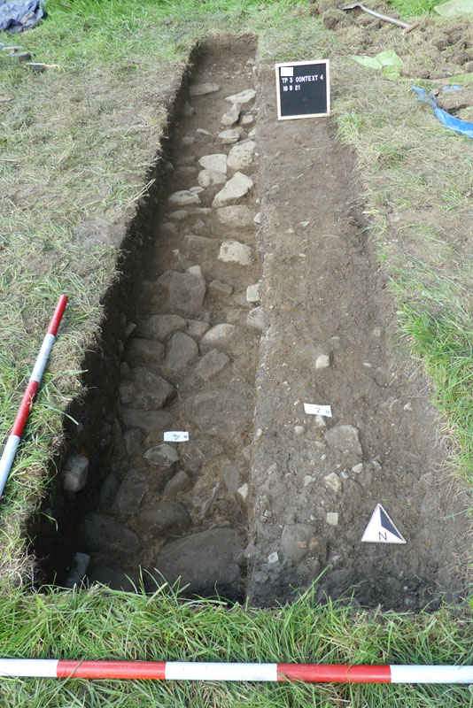
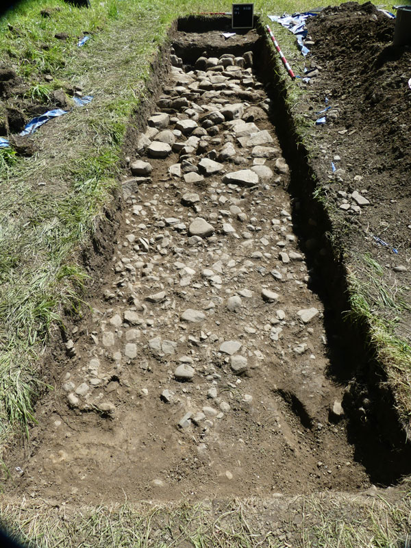
Over the course of the 14th to the 16th of September the previous 1m by 2m metre trench was re-excavated and progressively extended to the north finally reaching a length of 4 m with a width of 1m.
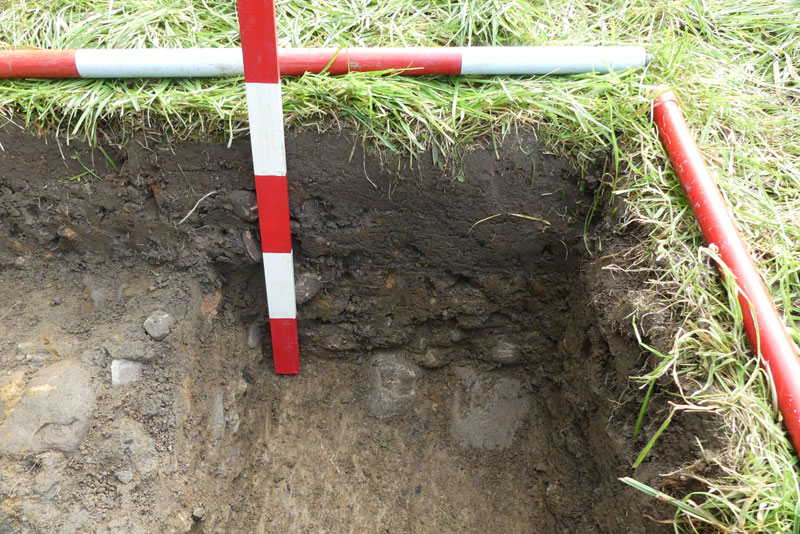
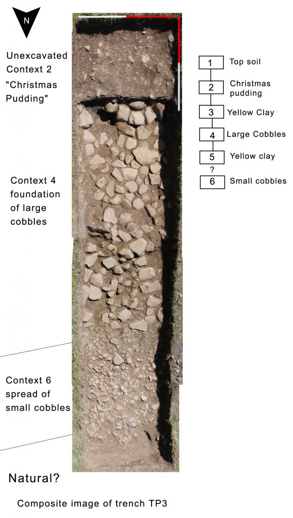
Below the top soil we again found the the mixed conglomerate of gravel, grit and clay now christened the “Christmas pudding layer” the trench was split in half and the western half excavated. Removal of the Christmas pudding revealed the clean yellow clay layer overlapping and between large cobbles. The Christmas pudding layer appeared to thin at the northern end of the trench (4m) and the large cobbles also looked to be reducing suggesting we might be close to the northern edge of the road. However there was no time to investigate further and plans were made to re-open and extend in 2022. Our final act before backfilling was to lift one of the large cobbles at the southern end of the trench and excavate a spade width and depth sondarge into the underlying yellow clay, which was clean and inclusion free suggesting it might not be the underlying natural.
On the left unexcavated “Christmas pudding” layer on the right.
May 16th to 19th 2022 Excavation
Methodology
Monday 16 May
At the end of the September 2021 excavation, pegs had been put into the ground and measurements taken to enable finding the trench. The trench area was identified and turf and topsoil were taken off, however it then began to rain very heavily so further activity was abandoned.
Tuesday 17 May
As infill was taken out it became clear that this trench was now actually about ½ metre to the west of the September 2021 trench. It was relatively easy to expose the large cobble layer on the east side of this trench (which had been exposed on what was the west side of the trench in September 2021) however on the west side removal of turf and topsoil revealed more of the mixed conglomerate of gravel, grit and clay “Christmas pudding layer”. Where this was removed it revealed firstly the clay layer overlapping and between more of the large cobble layer revealed in September 2021.
The trench was extended to the south by 1m but only the turf and topsoil removed to expose the surface of the mixed clay/gravel/grit layer; no further excavation of this area was undertaken.
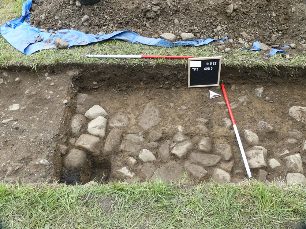
The trench was extended to the north beyond the limits of the 2021 trench to try and ascertain the edge of the large cobbles and hence the agger. Unexpectedly this revealed a spread of small cobbles, all generally smaller than 15cm and this layer appeared to be only 1 cobble thick.
Wednesday 18 May
The trench was extended further to the north progressively revealing more of the small cobble layer. This layer appeared to have an edge approximately 1m from a line which appeared to mark the northern edge of the large cobbles.
There were 4 larger stones overlying the small cobble layer and when they were lifted 3 of them were found to be resting on loose soil above the small cobbles. These stones were interpreted as having been dislodged and moved north, possibly by ploughing. Clay was found below the 4th and smallest stone and so that was probably part of the small cobble layer.
There was insufficient time to determine the precise relationship of the large and small cobble layers to each other or to any underlying stratigraphy. The mixed conglomerate of gravel, grit and clay appeared not to extend over the small cobble layer which was overlain only by topsoil and turf.
Thursday 19 May
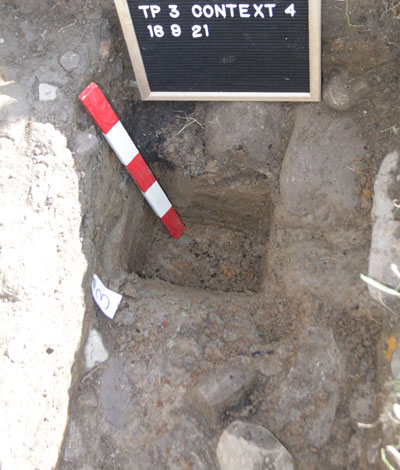
In the rest of the trench the layer of mixed conglomerate of gravel, grit and clay was removed, firstly to fully reveal the clay layer above and between the large cobbles and then this was fully removed to fully expose the large cobble layer. The trench was then generally cleaned up for photographs. The southern end of the large cobbles and the cobble spread at the northern end were also drawn at 1:10.
Because the north end of the trench appeared to have no stones, and natural had been reached, a 1m x1m test trench 4 was dug 1.1m from the north end of trench3. Whilst there were some stones in it, once the upper layer of soil had been removed they were not in any particularly order. A small sondage was dug which showed only the presence of clay
Discussion
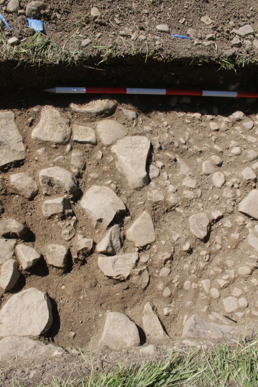
What was found confirms the general sequence suggested by previous test pits and other trenches. This being a foundation layer of large cobbles 20cm to 30cm (context 4) lying on a layer of stone free yellow clay (context 5) which might either be an artificial mound as suggested by excavations conducted by other workers and our own very small sondages or was subsoil exposed at the time of construction. The true nature of this will only be elucidated by further work. More stone free yellow clay was packed between and partially overlapping the large cobbles (context 3), presumably to stabilise and level the surface. Above this was a layer christened the “Christmas Pudding Layer” (context 2) because it looks like a deliberate mix of gravel, grit and clay. This layer survived to a depth of 20cm at the southern end of the trench and gradually thins to the north and comes to an end at the northern edge of the large cobbles. These last two layers coupled with the possible clay mound can be interpreted as forming the traditional Roman road Agger at this location. The principal layers exhibit the gentle curvature one would associate with a road camber.
The multiple extensions of the trench to the north to find the agger edge revealed something of a surprise which was a spread of small cobbles 5cm to 10cm in size (context 6). This layer of approximately 1.4m wide and had a very definite edge to the north and appeared to butt up to or slightly underlie the large cobble layer. There was insufficient time to establish the exact relationship. As this spread was first revealed the first thoughts were that it was the stone component eroded from the mixed clay/gravel/grit layer, however as it was fully revealed this interpretation looked increasingly unlikely as the deposit is very uniform, has an abrupt edge, and appears to be only one cobble thick, (yet to be established by excavation) all suggesting deliberate construction. A very quick literature search and conversation with other workers suggests the presence of a feature like this has been found in urban contexts but not rural.
There was no evidence of a ditch in the main trench or in the test pit to the north, however it is unlikely we would be able to observe any evidence of a ditch without opening a large extension of the trench to the north and even then it might require a machine cut section to reveal a ditch.
Future work
This trench will need to be re-excavated to complete the planning of the large cobbles and to draw the sections. The relationship of the gravel spread with the rest of the stratigraphy will need to be established. The opportunity should also be taken to extend the trench south to establish the full width of the agger, test for a southern gravel spread and possibly detect if the road was built on a terrace cut into the natural slope.
Interestingly there was a hint of the existence of another gravel spread in a test pit in an adjacent field. Establishing if this is correct would suggest this is a feature of our road and something possibly unusual about our road.
Lesly Marklew, Trevor Marklew and Barrie Tyrer 26 June 2022